The 2023 CARIBE WAVE exercise in the Caribbean and Adjacent Regions
Over 420,000 people from Bermuda through Brazil and Mexico through Barbados participated in the twelfth annual tsunami exercise CARIBE WAVE 23 held on 23 March 2023. The region has had a long history of devastating tsunamis and the exercise helps at-risk communities to prepare for this infrequent, but high impact hazard. The exercise is organized within the framework of the UNESCO/IOC Intergovernmental Coordination Group for Tsunami and Other Coastal Hazards Warning System for the Caribbean and Adjacent Regions (ICG/CARIBE-EWS). Its CARIBE WAVE task team through the NOAA International Tsunami Information Center Caribbean Office with the support of the Caribbean Tsunami Information Center and the Pacific Tsunami Warning Center coordinates this annual tsunami exercise.
Two hypothetical scenarios were simulated for CARIBE WAVE 23, a tsunami generated by a magnitude 7.6 earthquake located in the Gulf of Honduras and a tsunami generated by a flank collapse in Mount Pelée volcano, Martinique. The volcanic scenario was used to test experimental procedures and products for a tsunami generated by volcanic activity. It was up for each of the 48 Member States and Territories to choose between the two scenarios and decide the level of participation and activity for their country.
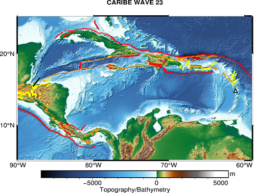
Map of the CARIBE WAVE 23 scenarios. The black rectangle indicated the map view of the ruptured fault segments for the Gulf of Honduras scenario and the black outlines triangle indicated the Mount Pelée scenario location.
The Pacific Tsunami Warning Center (PTWC), the regional Tsunami Service Provider (TSP), and the Central American Tsunami Advisory Center (CATAC), a proposed TSP, issued a “Dummy” message at 1400 UTC through the different warning systems to start the exercise and test communications with the Tsunami Warning Focal Points (TWFPs) and the National Tsunami Information Centres (NTWCs). As of 1407 UTC, the PTWC and CATAC issued through email the simulated tsunami products to officially designated TWFPs and NTWCs based on the two hypothetical scenarios. Each country then decided if and how to disseminate messages in their area of responsibility.
CARIBE WAVE is carried out with the purpose of validating and advancing tsunami resilient communities in the region and supports one of the indicators of the UNESCO IOC Tsunami Ready Recognition Programme. According to tsunamizone.org, of the over 420,000 registered people, 175,205 were from the French islands (Guadeloupe and Martinique), 129,471 were from Puerto Rico and 54,949 from Venezuela. The majority of the participants from across the region were from K-12 Schools and Districts. State Government and Colleges and Universities also had high levels of participation as well as a significant number of businesses, health care organizations, hotels and tourism and volunteer radio groups. A marked increase of people with disabilities was also noted. Full-scale exercises, seminars, and communication tests were some of the many activities that were organized for CARIBE WAVE.

Dr. Charles McCreery, PTWC Director, sending out the simulated tsunami products during the exercise.

ITIC-CAR contractors reviewing a local evacuation map during CARIBE WAVE 23.

ITIC-CAR Manager, Christa von Hillebrandt-Andrade, discussing details of the exercise with the Commissioner of the Puerto Rico Office of Emergency Management and Disaster Response

The interim mayor of Mayagüez, Jorge L. Ramos Ruiz walks the tsunami evacuation route with a student with disabilities from the Ruiz Belvis school and his teacher.

In Colombia From the National Tsunami Warning Center #CNAT, they put to the test the effectiveness of inter-institutional coordinations, the flow of communications and possible decisions to be taken in the face of an underwater volcano eruption.

The exercise allowed them to evaluate the updates made the previous year, by the entities that together with the Colombian Maritime Authority make up the National Tsunami Detection and Warning System, the National Disaster Risk Management Unit and the Colombian Geological Service.

Caribewave23 exercise in Panama
Caribewave23 exercise in Costa Rica
By Stephanie Soto and Christa von Hillebrandt-Andrade, UNESCO/IOC-NOAA International Tsunami Information Centre Caribbean Office